Exploring Building Boundary Expansion in NYC's Gowanus District : Focused on Multifamily Housing Development with Revised Zoning Regulations
Abstract
This article investigates recent trends and transformative impacts of multifamily housing projects in Gowanus, NYC, aiming to provide insights for urban development practices in the broader Metropolitan area. The Gowanus neighborhood in Brooklyn, New York, presents a dynamic urban landscape where multifamily housing development significantly influences urban planning, community dynamics, and the remediation of the polluted Gowanus Canal area. With a specific focus on waterfront boundary openness, the article conducts a strategic analysis of multifamily housing programs and their effects on public access. It traces Gowanus's historical evolution from its industrial past to its current state, examining the influence of revised zoning regulations and the city's comprehensive planning framework.
Through an in-depth exploration of multifamily housing development strategies, this article proposes approaches that utilize building boundaries to enhance continuity, facilitating the remediation of polluted areas, and presenting a comprehensive ground-level perspective. By examining real-world applications and highlighting the 300 Nevins Street case, the article not only demonstrates the potential for urban revitalization and resilience in the face of environmental challenges but also showcases progress in preserving place identity of post-industrial heritage.
The article concludes by underscoring the positive outcomes of strategic waterfront development, emphasizing its profound impact on community growth and environmental sustainability in Gowanus. It serves as a testament to the successful integration of multifamily housing initiatives contributing to the area's ongoing transformation and offers valuable insights for urban development at both local and metropolitan scales.
Keywords:
Gowanus, Post-Industrial, Multifamily Housing, Public Access, Waterfront Access키워드:
탈산업, 공동주택 재개발, 공공경계, 수변공간, 개방성1. Introduction
1.1. Objective of Study
The primary objective of this study is to conduct a comprehensive analysis of multifamily housing development strategies in Gowanus, a neighborhood in Brooklyn, New York. Gowanus represents a unique urban landscape with a historical backdrop of industrialization and ongoing environmental challenges, while simultaneously experiencing significant urban transformation. This study places particular emphasis on examining the transformative impact observed in the landmark 300 Nevins case.
The overarching purpose of this research is to shed light on the profound influence of multifamily housing development on urban dynamics and community growth in the context of Gowanus. Specifically, we aim to explore how strategic architectural planning and development strategies can harness the potential of post-industrial sites to generate positive impacts on the community while addressing challenges related to gentrification. Gowanus's multifamily housing development, characterized by a commitment to public access and innovative urban planning, serves as an inspiring example of urban revitalization and resilience.
Through this analysis, we seek to extract valuable lessons and insights that extend beyond Gowanus and can offer guidance to other urban areas, particularly within the broader Metropolitan region, facing similar urban challenges, particularly in the context of Brownfields and the complexities of gentrification.

Location of Gowanus canal, Gowanus frame work, NYC Department of City Planning 2018.
1.2. Method and Range of Study
In this study, we employ a multifaceted approach to gain comprehensive insights into the multifamily housing development strategy in Gowanus.
Explore Historical Context: We delve into the historical evolution of the Gowanus neighborhood, tracing its journey from an industrial hub to its current state. This exploration seeks to uncover how historical factors have shaped the area's development needs and character.
Review Previous Proposals and Studies for Gowanus Canal and analyze Regulatory and Planning Framework: Our study explores the influence of revised zoning regulations and the city's comprehensive planning framework on the multifamily housing development strategy in Gowanus. We assess how these regulatory changes align with the historical and environmental context of the neighborhood.
Investigate Waterfront Development Strategies: Delving into the strategic approach to waterfront development in Gowanus, considering its historical significance, is a crucial aspect of our research.
We conduct an in-depth case study of the 300 Nevins block development, contextualizing it within Gowanus' historical and environmental narrative.
This comprehensive research approach allows us to provide a nuanced understanding of multifamily housing development in Gowanus, differentiating our study from previous research and offering valuable insights into this transformative urban development.
2. Historical Context & Collaborative Solution
2.1. Environmental Challenges
Gowanus experienced rapid industrialization in the 19th and early 20th centuries. The area became a thriving industrial hub, hosting a wide range of manufacturing and industrial activities. Notable industries included gas production chemical manufacturing printing and various forms of heavy industry.
One of the major industries in Gowanus was coal gas manufacturing which involved producing gas for illumination from coal. This process generated significant pollution including coal tar which contained hazardous chemicals like benzene toluene and naphthalene. Several chemical factories in the area were known to discharge toxic substances into the soil and water. These discharges included heavy metals solvents and other hazardous chemicals. Factories routinely discharged untreated waste water and industrial byproducts directly into the Gowanus Canal. This practice contributed to the severe contamination of the canal. The cleaning up process and gentrifying the neighbor become simultaneous problem for the Gowanus district which was underlined in other studies over a decade[1].

Prior study on Gowanus site development strategies
2.2. Collaborative Solution of Gowanus
Over the years the Gowanus community in collaboration with government agencies and environmental organizations, recognized the urgent need to address these challenges. Efforts have been made to clean up the canal revitalize brownfield sites improve stormwater management and create green spaces. The neighborhood's transformation has been driven by a commitment to environmental sustainability and the desire to create a more livable and healthier urban environment for residents. These efforts have played a crucial role in the ongoing revitalization of the Gowanus area (Table 2.).
Government studies on Gowanus district planning
The Superfund designation for the Gowanus Canal has been a critical step in addressing the environmental challenges in the area. It has led to a coordinated effort involving federal state and local authorities as well as private property owners to clean up the canal and revitalize the Gowanus neighborhood. This designation has played a vital role in preparing the area for redevelopment including multifamily housing projects[2].
The Gowanus Canal was historically used as a combined sewer overflow (CSO) point, meaning that stormwater runoff and sewage were released directly into the canal during heavy rainfall, leading to water pollution. To mitigate this issue, the New York City Department of Environmental Protection (NYC DEP) and other relevant agencies have undertaken a series of infrastructure improvements. The Gowanus Canal area has seen the construction and upgrade of sewage pump stations to prevent CSO discharges into the canal. These pump stations are designed to capture and divert sewage and stormwater to wastewater treatment plants, preventing contamination of the canal.
These infrastructure enhancements are pivotal elements within comprehensive initiatives directed at purifying the Gowanus Canal, reinvigorating the surrounding neighborhood, and preparing it for forthcoming developments, notably multifamily housing projects. They wield substantial influence in forging a cleaner and more sustainable environment within the vicinity. Furthermore, these improvements are intricately interwoven with collaborative endeavors that encompass both public and private stakeholders deeply committed to the revitalization of Gowanus. Fig. 2. provides an overarching view of the cooperative synergy shared by government agencies and the community, accentuating their mutually complementary roles in this undertaking. When contemplating sustainable design practices for post-industrial sites, it becomes imperative to consider how cities and structures can remediate prevailing degradation while simultaneously replenishing depleted natural resources. Gowanus serves as an exemplar in this regard, showcasing how the restoration of post-industrial areas can concurrently remediate these locations while propelling their redevelopment[3].

Gowanus planning processes and milestones, by author.
2.3. Zoning Changes and Rezoning Efforts
The Gowanus Neighborhood Plan strategically incorporated rezoning initiatives and modifications to zoning regulations, aligning with the broader trend in NYC comprehensive waterfront plan 2021, to repurpose industrial zones around waterfronts for multifamily housing and mixed-use developments through up-zoning measures. These changes were designed to transform Gowanus into a more vibrant and inclusive neighborhood. Here's how these rezoning efforts impacted the post industrial waterfront and multifamily housing development[4].
1) Introduction of Mixed-Use Zoning: One of the primary changes was the introduction of mixed-use zoning in Gowanus. This allowed for a more diverse range of land uses within the same areas, including residential, commercial, and industrial uses. Multifamily housing projects were encouraged as part of this mixed-use approach[5].
2) Increased Density in Key Areas: In specific zones, density allowances were increased, enabling taller buildings and a greater number of housing units. This change aimed to accommodate the growing demand for housing in the neighborhood.
3) Inclusionary Housing Requirements: Inclusionary Housing (IH) regulations were introduced to encourage developers to include affordable housing units within their multifamily housing projects. Developers were given incentives, such as additional density allowances or financial benefits, for providing a certain percentage of affordable housing units within their developments[6].
4) Waterfront Development: Throughout previous studies on waterfront development in lower Manhattan, the development strategies were assessed and highlighted at various scales, ranging from the project and community levels to urban and regional-scale connections[7]. Zoning adjustments along the Gowanus Canal waterfront aimed to create a more inviting and accessible environment which is focused on both individual specifics and community scale. These modifications included the potential for mixed-use developments, waterfront parks, and pathways, enhancing the overall attractiveness of multifamily housing projects in the vicinity. This aligns with the city's vision of rejuvenating the post-industrial area, especially the waterfront, with multifamily housing playing a pivotal role. Fig. 3. illustrates the industrial zoning districts naturally present around the waterfront areas, highlighting their potential for redeveloping, while Table 3. outlines the locations of significant developments featuring residential programs in recent years.

Industrial zoning districts of Manhattan, Brooklyn and Queens mainly located around waterfront of Metropolitan area, NYC The Open Accessible Space Information System (OASIS).
Redevelopment Projects with Waterfront Developments in NYC, Industrial area (2015- current)
5) Affordable Housing Preservation: The plan also focused on preserving existing affordable housing units in the neighborhood, especially in older multifamily buildings. This involved measures to ensure that these units remained affordable and available to low- and moderate-income residents.
6) Green Building and Sustainability Standards: Zoning regulations were updated to encourage green building practices and sustainability. This not only included energy-efficient design but also green infrastructure and stormwater management, which are crucial for multifamily housing developments.
7) Public Spaces and Amenities: Zoning changes promoted the creation of public spaces and amenities within or adjacent to multifamily housing projects. These could include communal gardens, rooftop spaces, and areas for community interaction, enhancing the overall quality of life for residents.
8) Artistic and Cultural Provisions: The zoning changes encouraged the integration of artistic and cultural elements within new multifamily housing projects. This could involve art installations, creative spaces, or cultural venues, contributing to the neighborhood's artistic vibrancy.
Gowanus district is the largest rezoning area in 10 years which is approximately 200 acres. This will add 8,500 units with 3,000 affordable units to the city. These projects vary in size, scale, and location, but they share the common goal of addressing housing needs, promoting affordability, and contributing to the development of dynamic and inclusive neighborhoods in the New York City area[8].
Analysis table of multifamily housing in Gowanus
2.4. Public Participation and Local Voice
Previous articles and studies shed light on the impact of visual and virtual symbols on this area, contributing to gentrification and the decline of industrial ecology. These negative consequences are intricately linked to governmental messages and notations in politics, economics, and agenda-setting. This process occurred concurrently with the Superfund cleanup and gentrification in Gowanus[9].
The voices of residents and the public vision have been explored through design competitions held by ‘Gowanus by Design’, which fall under the category of architectural or urban design contests. These series of competitions invite professionals, architects, and planners to submit innovative proposals for specific projects or areas within the neighborhood. The primary goal of these competitions was to cultivate creative and forward-thinking ideas for urban development, addressing the challenges and opportunities present in the community[10].
The effectiveness of community engagement in Gowanus' space planning is challenging to generalize, and there have been criticisms regarding how the city has handled public feedback. The diverse opinions and perspectives within the community make it difficult to draw universal conclusions about the impact of community engagement on the planning process. Additionally, critiques have been raised regarding the city's approach to incorporating and responding to public input. The dynamic nature of community engagement and urban development often involves navigating a range of viewpoints and challenges in achieving consensus[11].
In Gowanus, the implementation of strategies for the New York City Housing Authority (NYCHA) and targeted outreach has played a significant role in engaging the public and fostering positive feedback. These efforts aim to facilitate collaboration and encourage community involvement in the development process, fostering a sense of shared growth and development. The focus on specific outreach initiatives helps ensure that the community's diverse voices are heard and considered, contributing to a more inclusive and responsive approach to urban development in Gowanus.
2.5. Multifamily Housing in Gowanus
The redevelopment of industrial facilities in Brooklyn has yielded varying results across different neighborhoods. In particular, the nature of redevelopment has taken on different characteristics depending on whether the developers and owners of industrial facilities are corporations, individuals, or government entities. Furthermore, the impact on the lives of the original residents has been significantly different depending on whether the focus of the project is on public-oriented development or private development[12].
Multifamily housing projects developed by private developers in Gowanus have been a key driver of the neighborhood's transformation, attracting new residents, businesses, and investments. They have provided housing options to meet the diverse needs of a growing population while contributing to economic vitality and environmental sustainability. These projects have played a crucial role in addressing the demand for housing in New York City and making Gowanus a more inclusive and livable urban environment.
Government involvement in post-industrial redevelopment is critical, primarily through the development policies, and tax policies. Tax policies have played a critical role in encouraging redevelopment in Gowanus. One significant tax policy that influenced development in the area was the 421-a tax incentive program, which provided tax benefits to developers who included affordable housing in their projects. The expiration of 421-a program on June 15, 2022, was a milestone moment leads the developers to file-in and start construction at a similar time in this area. Fig. 4. illustrates new multifamily housing projects in the Gowanus district, including affordable units, with the expectation of incentives. A total of 14 projects were filed during the 2021-2022 period. To gain all the tax benefits, most of the projects are in construciton as of 2023 and expected to be finished by 2025.

Incentives and Requirements of Mixed-Use Building, Max 5.0 FAR, diagram by author.
3. Boundary Use Strategies in Gowanus
Chapter 2 illuminates Gowanus' historical journey, navigating through environmental challenges, collaborative solutions, and the influential role of zoning changes in shaping the neighborhood. As we transition to Chapter 3, the focus sharpens on the symbiotic relationship between the post-industrial city context and emerging residential community programs. Emphasizing 'Openness' and 'Continuity,' Chapter 3 intricately explores the expansion of building boundaries within the framework of revised zoning and waterfront access plans. This evolution is not merely a spatial transformation but a conscious effort to weave together the industrial heritage, city context, and the vibrant spirit of a new residential community. The chapter delves into how these strategies foster a dynamic interplay between the built environment and the evolving needs of the community, seamlessly bridging the past with the future in Gowanus.
The author wants to suggest ‘Openness’ and ‘Continuity’ as main factors to improve boundary of new developments in Gowanus district. Under the new zoning text. And based on the Gowanus Framework analysis in 2018 and the presentation to the City Planning Commission in 2021, our focus is to comprehend the impact of buildings on the neighborhood by examining waterfront access plan.
The revised zoning regulations in Gowanus introduce a significant program incentive, permitting an additional 0.6 Floor Area Ratio (FAR). Fig. 4. shows comparison between the previous and revised zoning conceptual program allocated on the ground floor. This initiative actively promotes mixed-use development, encompassing communal, cultural, and light-industrial programs. Aligned with the expressed desires of the local community, this incentive anticipates heightened community involvement and, by attracting the 'creative class,' directly contributes to the cultural and economic success of Gowanus[13].
The subsequent subsections detail the key components of this design strategy, elucidating how 'Continuity,' 'Openness,' and the concept of 'Place-ness' contribute to a holistic and integrated approach, shaping environments that seamlessly blend communal, cultural, and light-industrial programs. Through this exploration, we seek to provide valuable insights into the nuanced considerations involved in the design of vibrant and interconnected waterfront spaces.
3.1. Continuity
Integrating space, structure, program, and infrastructure in Gowanus can greatly enhance building functionality, especially when harmonizing them with the urban context and the ongoing narrative of the waterfront. This integration plays a crucial role in achieving Gowanus's objectives for waterfront access, highlighting the significance of expanding public spaces and embracing a dynamic landscape concept. The continuous circulation of people creates opportunities for events and enriches the architectural experience, making architecture a platform that blends imagery with reality. This can be a ‘Field Condition’ that was defined as any formal or spatial matrix capable of unifying diverse elements while respecting the identity of each[14].
Fig. 5. illustrates the strategy of waterfront access with potential visual and physical ‘corridor’. This approach is essential for connecting each sub-area to waterfront and, indentifying the community with related light-industrial programs in new developments .

Waterfront access plan of Gowanus canal, NYC Department of City Planning 2021.
3.2. Openness
The intentional deployment of boundary spaces in Gowanus, particularly with respect to waterfront access, revolves around critical elements like openness and the allocation of public areas. Delving into design strategies, it becomes evident that projects embracing a comprehensive boundary approach, integrating horizontal spaces with parks, showcase heightened levels of openness and public space distribution.
The concept of “openess” of the building not limited to public space, but can be extended to the inside and blended with the outside. Contradiction between the inside and the outside may manifest itself in a “lining”- that is, a space within a space analogous to its frame. Layers between the inside and the outside can be more or less contrasting in shape and position, pattern and scale[15].
Fig. 6. is a diagrams of ground floor showing the potential ‘in-between’ space generated by inserting an open space to a building. It can be transformed into greenery to create visual openness, and spaces like squares can be established to provide citizens with areas for relaxation. Crucially, these spaces should not be rigidly defined with fixed functions or fixed spaces but should allow for new experiences based on user flow, time, and events. Boundary spaces must have independent functions while necessitating dynamic connections with the interior of the building to truly hold significance planning.

Additional open space connecting building programs on ground floor with pedestrians, diagram by author.
Fig. 7. illustrates that taller buildings result in a more open site, as dictated by the given Floor Area Ratio (FAR). However, an equally critical factor influencing spatial continuity is the building boundary and its corresponding ratio. Gowanus is portrayed with a ground floor that is more occupied compared to other developments. Interestingly, this contributes to an expansion of the active boundary area, establishing vital connections to public circulations.

Verticality and site coverage comparison chart, by author.*Building Cover Ratio = FAR / Building Floors
3.3. Place-ness
Place-ness is a concept denoting the distinct identity or character inherent to a particular location. It suggests that our perception and recollection of a place involve pre-existing familiarity with the surrounding environment and elements. Consequently, defining a place necessitates the establishment of connections in both the physical and mental realms to acquire a sense of place.
In this post-industrial site with a rich industrial heritage, materialism and architectural tectonics are pivotal. The challenge lies in preserving historic streetscapes, manufacturing, and active industrial sites while enabling economic revitalization and activating underutilized areas. The proposal for a National Heritage Corridor offers collaboration potential and underscores the significance of defining the area's "place-ness" from diverse perspectives[16].
4. Case Study
The 300 Nevins Street project, designed by Fogarty Finger Architecture, serves as a compelling case study, with the author engaged in zoning and building department filing processes. This study aims to assess the integration of key categories Affordable Housing, Waterfront Access Plan, Sustainability & Resiliency, and Special District incentives into the planning, design, and coordination with landscape elements. Table 5. shows basic analysis includes evaluating the FAR, site boundary length, and ground floor continuity to establish an openness ratio for the buildings, offering a comparative metric against other waterfront developments in Metropolitan areas. The generated analysis tool will be applied to make informed evaluations.
300 Nevins Steet zoning analysis table
4.1. Zoning Analysis of 300 Nevins
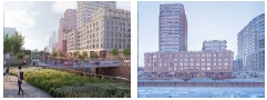
The 300 Nevin Street multifamily housing project in Gowanus is a prominent development that combines residential and community-oriented elements with a focus on flood control and sustainability. Here are the key features of this signature project. The project is situated in Canal Corridor block of the Gowanus Canal, making it a significant part of the waterfront revitalization efforts in the area. This two-tower project comprises more than 650 residential units, retail spaces, and community programs, creating a vibrant and self-contained community within the neighborhood.
4.2. Green Buffer and Flood Control
The development includes a raised waterfront deck that provides green space for residents while also serving as a flood control measure (Fig. 8.). The design raises the entire site by more than 11 feet to accommodate potential flooding, enhancing the neighborhood's resilience to water-related challenges. Field Operations designed the landscape of 300 Nevins, incorporating multiple waterfront platforms resembling ‘barges’ as concept. The strategic inclusion of a green buffer not only enhances the site aesthetically but also plays a crucial role in flood control. This eco-friendly feature serves as an ecological filter, contributing to flood mitigation and reducing pollution in the adjacent canal.

Flood control diagram of 300 Nevins St.: 11’ above base plane set by Fogarty Finger Architecture.
4.3. Waterfront Access Plan (Continuity and Openness)
The project aligns with the city plan and zoning regulations, ensuring consistent setbacks and daylight patterns that contribute to the overall urban design and livability of the Gowanus area. The ground level features retail and light industry programs, along with public access, 50’ wide upland connection from the neighborhood to the waterfront (Fig. 9.). This demonstrate the idea of the ground floor planning concept, which is open to the public, connecting seamlessly to the open park with multiple access points.

Ground floor plan of 300 Nevins St.: Enhancing accessibility from the public boardwalk, contributing to continuity. (Source: NYSDEC, Work Plan of Brownfiled Cleanup Prgram)
In this project, two additional inner courts can be also found serving the non-residential, retail programs which are located on the entire ground floor except for the residential entrance (Fig. 9.). These additional elements are connecting the pedestrian of the waterfront walkway to community places such as non-commercial Art galleries. The podium portion of the building and those circupation through inside out space will be potential ‘anchor spaces’ to activate public uses and integrate creative class of the neighbor (Fig. 10.).

Axonometric diagram of 300 Nevins St. by Fogarty Finger Architecture.
This design philosophy having additional public platform serves as a cornerstone in forging connections among community programs, light-industrial initiatives, and residents with public spaces. The emphasis on openness not only fosters awareness but also stimulates active engagement within the Gowanus neighborhood, aligning with the overarching goals of macro city programs.
4.4. Design Aesthetics (Place-ness)
The facade design draws inspiration from the architectural elements of old factory buildings (Fig. 11.), and nearby water pump structures. A series of over-sized arches on the ground floor provide character of the storefront with brick elements on the podium level. Prefabricated modular design is applied to the facade of tower portion, and rounded corners give the project a contemporary feel while paying homage to its industrial heritage (Fig. 12.).

Façade of industrial heritage , photos from MASNYS.[17]

Over-sized arch in 300 Nevins podium, and tower façade, designed by Fogarty Finger Architecture.
It requires a delicate equilibrium, harmonizing the conservation of distinctive historic street-scapes, ongoing manufacturing activities, and active industrial sites with the essential modifications for economic revitalization and the activation of dormant areas. While Gowanus's identity is deeply tied to its historic industrial landscape, historic preservation hasn't been a primary focus of community endeavors[14].
The comprehensive development of 300 Nevins, encompassing both facade design and landscape integration, serves as a commendable example of how to engage with the historic industrial character of the neighborhood. It adeptly amplifies the imperative for preservation recognizing the significance of buildings where people have borne witness to the historical fabric of the area.
4.5. Summery and Discussion
By analyzing 300 Nevins Street, practical insights into the implementation of these architectural elements emerge. Detailed numerical analysis, as presented in Table 6., provides insights into the key strategies employed in the 300 Nevins waterfront development featuring multifamily housing.
300 Nevins St. strategy analysis table
The 300 Nevins Street project demonstrates alignment with city planning objectives and meaningful connections with the community. Unlike high-rise developments in other waterfront areas with disconnected open spaces, Gowanus's development adopts a more streetscape-oriented approach with mixed-use programs throughout the neighborhood. Especially the emphasis on waterfront access and the strategic use of architectural boundaries play a pivotal role in shaping the city's context.
This case study illustrates how architects and designers play a significant role in shaping the neighborhood's identity and symbolism. Designing with empathy, openness, and a connection to heritage establishes a meaningful dialogue between the past and present.
5. Conclusion
In conclusion, multifamily housing development in Gowanus signifies a transformative shift in urban planning, characterized by a robust commitment to sustainability and environmental considerations. This study highlights Gowanus's multifamily housing development, characterized by its dedication to public access and innovative urban planning, serving as an inspiring example of urban revitalization and resilience. Furthermore, it emphasizes the importance of the architectural narrative, focusing on continuity, openness, and a strong sense of place in the design of new multifamily housing projects. Beyond the physical structures, the success of multifamily housing development lies in the creation of intangible community bonds.
While the Gowanus programs show promise, a more comprehensive evaluation is necessary to assess synergies upon the completion of all projects. Throughout this study, it becomes evident that there is a compelling need for more detailed, project-specific evaluations when assessing multifamily housing strategies, as emphasized in this study. Additionally, it's important to acknowledge the limitations in gauging the actual impact on residents and community users within the scope of this study.
The lessons derived from this case extend beyond Brooklyn, offering valuable insights for metropolitan areas facing similar challenges. Gowanus serves as an exemplar of the potential for post-industrial sites not only to recover but also to flourish through a considerate integration of history, community engagement, and environmental stewardship.
References
- R.S. Krisel, Gentrifying a superfund site: Why Gowanus, Brooklyn is becoming a real estate hot spot, Consilience: The Journal of Sustainable Development, 14(2), 2015, pp.214-224.
- United States Environmental Protection Agency, Superfund site: Gowanus Canal - Background, https://cumulis.epa.gov/supercpad/SiteProfiles/index.cfm?fuseaction=second.Cleanup&id=0206222#bkground, , 2023.11.30.
-
T. Chin, Symbiotic urbanism: Looking beyond sustainability, 2018 ACSA/COAM International Conference: New Instrumentalities, 2018.06, pp.56-62.
[https://doi.org/10.35483/ACSA.Intl.2018.9]

- NYC Department of City Planning, Gowanus: A framework for a sustainable, inclusive, mixed-use neighborhood, 2018.
- NYC Department of City Planning, Gowanus Industrial Business Zone (IBZ) vision plan, 2021.
- NYC Department of City Planning, Affordable Housing and MIH in Gowanus, Presentation to Community Board 6, 2019
-
최정희, 김기연, 장경철, 뉴욕시 수변공간의 계획특성 연구, 대한건축학회논문집 계획계, 제25권 제9호, 2009.09, pp.241-248.
J.H. Choi, K.Y. Kim, K.C. Jang, A study on the characteristic of urban waterfront projects in New York City - Focus on the cases of Lower Manhattan -, Journal of the Architectural Institute of Korea Planning & Design, 25(9), 2009.09, pp.241-248. - NYC Department of City Planning, Gowanus neighborhood plan: City planning commission presentation, 2021.
- J. Krase, Symbolic icons: Conflicting visions of the Gowanus Canal, Urbanities: Journal of Urban Ethnography, 12(2), 2022.11, pp.62-78.
- Gowanus By Design, Gowanus axis civitas international competition, https://www.gowanusbydesign.org/axis-civitas, , 2015.
-
Z. Turan, Finding the “local green voice”? Waterfront development, environmental justice, and participatory planning in Gowanus, NY, Urbani Izziv, 29(Supp.), 2018, pp.79-94.
[https://doi.org/10.5379/urbani-izziv-en-2018-29-supplement-005]
-
박진빈, 브루클린 수변 산업지역 재개발 - 네이비 야드, 그린포인트, 레드 훅, 도시연구: 역사·사회·문화, 제34권, 2023.11, pp.35-62.
J.B. Park, Redevelopment of Brooklyn’s industrial waterfronts: Navy Yard, Greenpoint, Red Hook, Korean Journal of Urban History, 34, 2023.11, pp.35-62. [ https://doi.org/10.22345/kjuh.2023.11.34.35 ]
- M. Spitzer-Rubenstein, Gowanus gentrified? Community responses to gentrification and economic development in the shadow of the superfund (Doctoral dissertation), Barnard College, 2012.
- S. Allen, From object to field: Filed conditions in architecture + urbanism, In: Allen S, editor, Practice: Architecture, technique and representation, Oxford, UK: Routledge, 2009, pp.216-241.
- B. Tschumi, Spaces and events, in bernard tschumi, architecture and disjunction, Cambridge, MA: The MIT Press, 1994, pp.139-149.
- K. Daly, Preserving New York City’s waterfront industrial and maritime heritage through resilient and sustainable development, In: Willems WJH, van Schaik HPJ, editors, Water & heritage meterial, conceptual and spiritual connections, Leiden, Netherlands: Sidestone Press, 2015, pp.155-167.
- The Municipal Art Society of New York, Preserving the industrial heritage of Gowanus: Testimony to the landmarks preservation commission, https://www.mas.org/news/preserving-the-industrial-heritage-of-gowanus/, , 2023.11.11.